3D laser scanner architecture
3D Laser & LiDAR Scanning for Architects
Architecture: 3D Laser & LiDAR Scanning for ArchitectsLeading Architecture organizations use GeoSLAM for:
InsourcingArchitects may traditionally rely on surveyors to complete scans of properties, which can be expensive and time consuming.
ConvenienceTaking traditional static equipment to a large site isn’t convenient as multiple scans and site visits are required.
WorkflowFrom easy to use data capture, to full integration with existing workflows and software.
Operational optimization
Easy to adopt technology to benefit every part of the production cycle, without the need for a surveyor.
Why GeoSLAM?
- Save significant time when capturing information about buildings
- Everything you need in one visit
- Easy to use, no need to outsource your data capture
- Robust and accurate LiDAR hardware that can be used in low light and poor weather
- Automatic data processing using GeoSLAM Connect
Find your nearest dealer
Our experienced GeoSLAM dealers can help you with demos, pricing and questions about
how GeoSLAM can help you to capture geospatial data quicker and more easily.
GeoSLAM in action
“These are such amazing products. Saves so much time in measuring houses”.
Corey Jackson
Owner, Architectural Drafting & Design LLC
“What really stood out was the quality of information captured, which was easily incorporated into a BIM representation using REVIT software. The device was really easy to handle and it was remarkable how much detail we were able to capture in the point clouds. It enabled us to achieve a level of accuracy that would have been impossible with manual techniques.”
Jose Vargas
BIM Technology Consultant,
Paragram architecture and consulting
“The first improvement with the GeoSLAM laser scanner was time saving, you’re just walking at a relaxed pace through the building, and its doing the magic for you as far as capturing all of that data.
I don’t think that I’ve ever had one project where I got all the information that I needed, that’s another attractive piece about the GeoSLAM, that you can take one tool out into the field and get everything that you needed.
For us GeoSLAM was the perfect fit for architecture.”
Jordan JD Dixon
Architect, Project Manager, SLA Architects
Case Studies
Builders by Design, UK
Industry: Construction, engineering and architecture
Scanned: Residential property
Scan time:6 – 8 scans per day
Paragram, Brazil
Industry: Architecture
Scanned: Skyscraper
Scan time:10 hours
Size: 8,357 sq/m
Which ZEB
is right for you?
ZEB Go
Used mostly for scanning indoors or in underground mines and caves with an IP64 rating. Can be used for applications such as construction/BIM or creating floorplans. Can be used outdoors and has a range of 30m.
ZEB Revo RT
Real-time processing which means you can visualize the scan as you move. Has a range of 30m and IP51 rating. Used mostly for scanning indoors and utilized for applications such as construction/BIM or creating floorplans.
ZEB Horizon
The most flexible of the ZEB family with a range of accessories which makes it suitable for lots of different applications. Can be used to scan indoors and outdoors with a longer range of 100m. Collect data using a UAV or vehicle, or pair with a backpack and GPS antenna for precise location positioning.
The after sales package to get the most from your ZEB productsGeoSLAM Care comes as standard with each new product, and is a comprehensive after sales package where you’ll be entitled to:
- Hardware support – Up to 3 years hardware warranty to ensure your ZEB is always performing at its best.
- Remote Software Support – Unlimited software support from our expert engineers.
- Software Updates – Access to new software releases and all the latest features.
GeoSLAM Academy hosts all the resources and materials you need to get the most from your ZEB, and it’s free to any GeoSLAM user. Here’s some of the resources you’ll have access to:
- Hardware and software user guides
- Training videos
- Best practice guidelines
- How to use GeoSLAM data with third party software
- Webinar recordings
Find out more
Want to know how GeoSLAM can help you? Complete the form below and one of our experts will be in touch shortly.
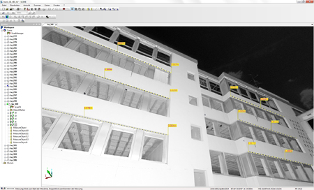
Autodesk Navisworks is a comprehensive project review solution that supports co-ordination, analysis and communication of design intent and constructability. The software can be used as a common data environment (CDM) for multidisciplinary design data created in a broad range of Building Information Modelling (BIM) packages.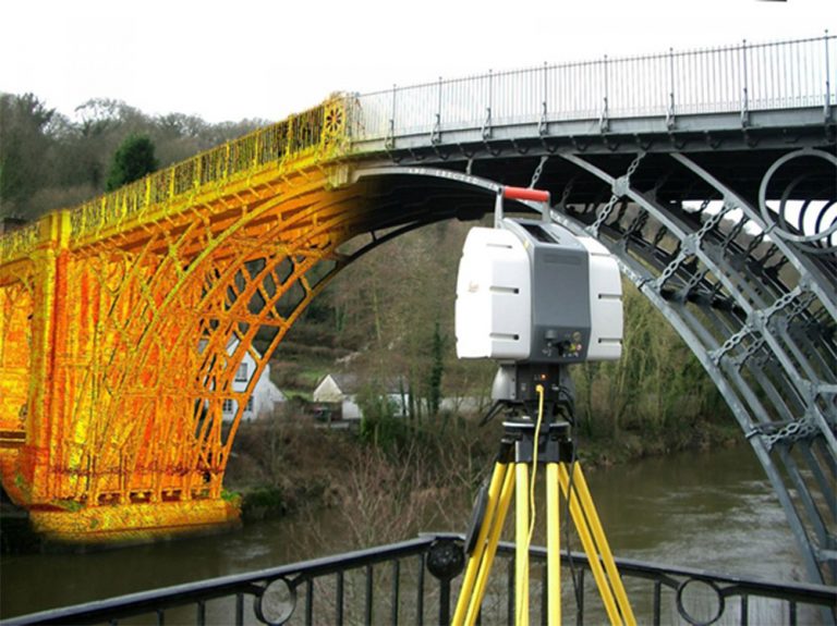 Using the tools within Navisworks, users can anticipate and minimize and potential problems between the physical building and the structural model.
Autodesk Revit is a building information modelling (BIM) software. It contains tools which allows for planning and tracking throughout the building’s lifecycle. The software also allows multiple disciplines to collaborate more efficiently and make more informed decisions early in the design process. As GeoSLAM’s hardware allows for quick data capture, the equipment can be used to scan any existing buildings with the purpose of using the data to produce a digital twin.
Click here to learn more about GeoSLAM and Revit
With the GeoSLAM Connect stop-and-go georeferencing feature, users can easily georeference headings from known positions and map for analysis of overbreak, underbreak, undercutting and blast roughness calculations. This information is used within Deswik Mapping to analyze headings and levels.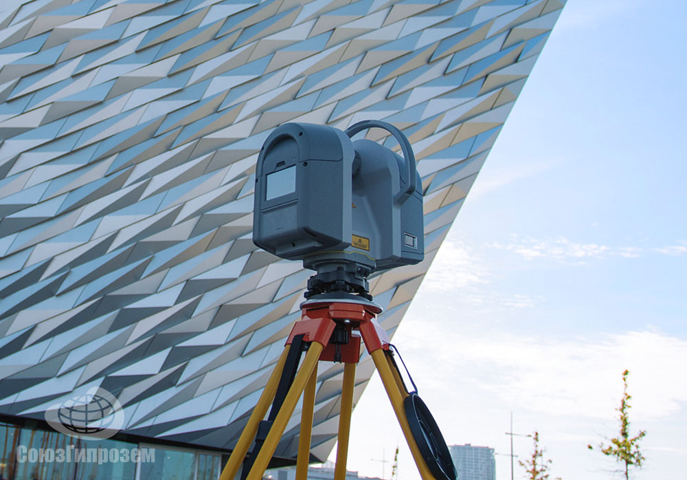
Outputs from GeoSLAM’s solutions can be input to Esri’s GIS programs and apps, including ArcPro, ArcDesktop, ArcGIS Online and ArcScene. Join point clouds with local geodata or classify and edit scans based on their geography and statistics.
GeoSLAM are proud to be silver partners of Esri.
Click here to learn more about GeoSLAM and Esri
GeoSLAM 3D point cloud data can be imported into Unity 3D Game Engine to generate interactive 3D scenes, where users can create 3D BIM models with textures and explore the space in 3D photorealistic environments.
Although Unreal Engine is mainly built for developing games, increasingly users are starting to use it to develop VR applications for understanding the current conditions of buildings, infrastructure and similar. Unreal Engine with a point cloud plugin can be used to visualize GeoSLAM point clouds in VR, which allows for collaboration, simulation and the understanding of current conditions of any scanned environment.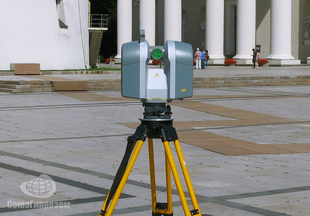 Additionally, Unreal Engine tools are completely free.
Arena4D is a software package for marking up, annotating and editing 3D point cloud data containing a various export capabilities. It has a powerful and simple to use animation package which allows users to visualize massive point clouds in a simple way. GeoSLAM data can be simply uploaded and used in this package for the assessment of the current conditions of any structure, comparing differences between captured data (as built) to designed model (as designed).
Pointfuse generates 3D meshes from point cloud data and classifies them to building ceilings, walls, windows and other features in IFC format. By using GeoSLAM data with Pointfuse users can very quickly create a classified BIM model with minimal manual input or expertise needed.
MineRP has a Spatial DB that uses GeoSLAM data to represent visually the real environment of the underground mine. The software uses other data layers to overlay information on the digital landscape for decision making and tracking.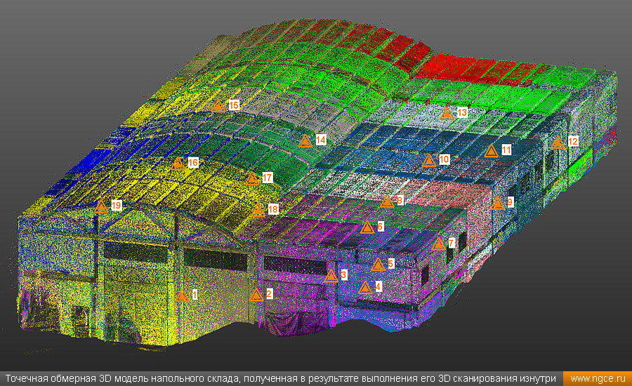
Nubigon is a software solution that allows users to seamlessly interact with large point clouds and create visualizations and animations. Take your GeoSLAM point cloud data into Nubigon to create eye-catching flythrough videos.
Pointerra provides a powerful cloud based solution for managing, visualizing, working in, analyzing, using and sharing massive 3D point clouds and datasets. Pointerra allows users to simply visualize and interrogate GeoSLAM data from anywhere.
Autodesk Recap contains tools for the manipulation and interpretation of high quality point cloud data and to aid designers and engineers in their creation of 3D models for real-world projects and assets (e.g. buildings and other infrastructure). It’s integrated design features help to streamline workflows, for example Scan to BIM. Recap is used to create initial design projects that users can then take into other Autodesk modules (e.g. Revit, Navisworks, AutoCAD).
Orbit GT allows users to capture and manage available 3D data (LiDAR data and imagery), extract a range of features for map production and make data sharable. All Orbit modules are ready to be used with 3D data from indoor, oblique, UAS and mobile mapping projects with other extensions that can be added to the Publisher and Orbit Cloud. Orbit can be used with the ZEB Discovery solution.
ContextCapture is a reality modelling tool, allowing for the import of any point cloud and imagery data for the creation of high resolution reality meshes. These realistic meshes are accurate representation in 3D with high resolution RGB values of any scanned environment. By using GeoSLAM data in ContextCapture the users are able to create indoor reality meshes, which has been never possible before.
Microstation is a 2D/3D software for designing building and infrastructure projects. It includes building information modelling (BIM) tools to document and assess any type of asset throughout its lifecycle. GeoSLAM solutions are often used in Microstation in the underground mining sector and to assess the current stage of any built environment, update the design model, and generate BIM information.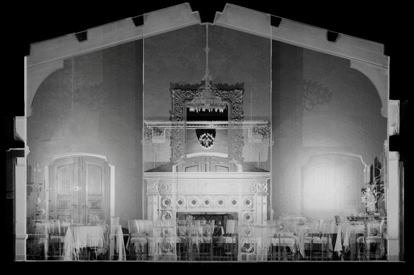
Micromine is a detailed and diverse mining software that provides solutions including modelling, estimation, design, optimisation and scheduling. Once data is exported from Connect it can be imported into Micromine and easily converted into wireframes. These can be used in Micromine for further studies into volumetric slicing, over and underbreak analysis, geologic modelling, face mapping and many more.
Click here to learn more about GeoSLAM and Micromine
Terrasolid provides tools for data processing of airborne and mobile mapping LiDAR data and imagery. It includes different modules for tasks like data manipulation, calibration, georeferencing, point cloud classification, modelling and many more. It is a very powerful tool for a variety of industries, surveyors, civil engineers, planners, designers. Full, UAV or lite versions of Terrasolid modules are available for both MicroStation or Spatix software. All GeoSLAM products are compatible with Terrasolid and GeoSLAM data can be enhanced and edited with this software.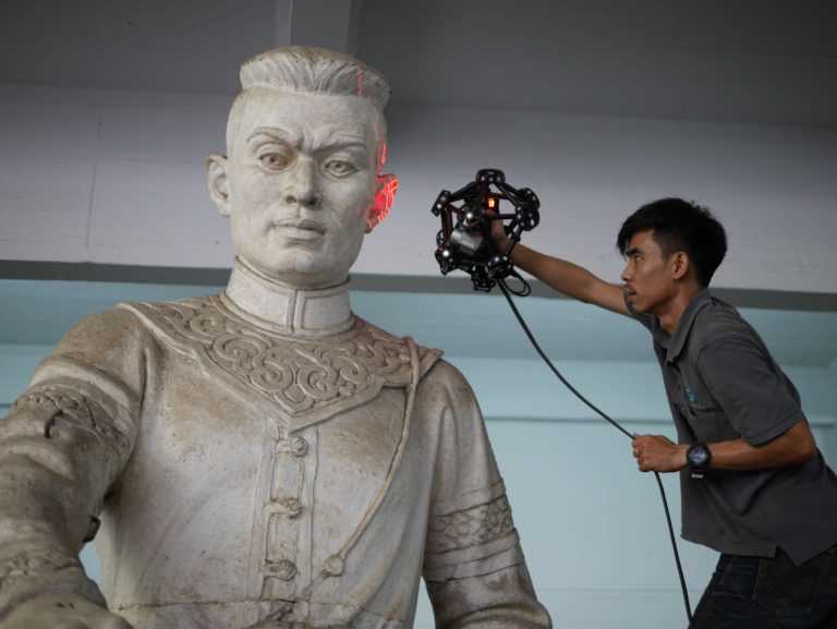
Floorplanner allows you to draw accurate 2D floorplans within minutes and decorate with over 150,000 items from kitchen appliances to tables and chairs. Data is exported from GeoSLAM Connect in PNG file format with a scale of 1cm per 1 pixel and can be taken into Floorplanner.
3D Scanning for Architecture, Engineering & Construction
From the design stage to the inspection stage, 3D scanning and measurement is an integral element of architecture, engineering, and construction. Our terrestrial scanning services can save you hundreds of hours on planning time and misspent labor.
Laser Design’s 3D terrestrial & LiDAR specialists have experience with new construction, renovation, historic preservation, and building inspection projects around the world. From historic homes to international airports, terrestrial scanning services is an ideal 3D as-built documentation solution for any building project’s needs.
Benefits of 3D Scanning Services:
- On-site 3D scanning of your site that is virtually unlimited in size and environment including broad daylight, the dark of night, indoors, and outdoors
- Receive complete documentation of existing as-built conditions
- Obtain permanent records for immediate or future uses
- Save time and cost by reducing your time with cameras and measurement devices
- Increase safety in unsafe locations
- 3D Scan and replicate sites and ornate details
- Verify architecture of floors, walls, buildings & more – this terrestrial (or static LiDAR) technology is great for the AEC/AEP world!
- and many specific benefits based on your industry and application!
3D Scanning Deliverables:
- 3D CAD Models
- BIM Integration
- As-built Documentation
- Fly-through and presentation capabilities with more accuracy than photos or video alone
- Point Cloud Data
- Elevation Drawings
- Plan View Drawings
We also sell long-range Artec Ray for your long-ranging scanner needs!
Contact us!
Ask a 3D Expert - Microsite
What is 3D Terrestrial Scanning?
Terrestrial & Mobile 3D scanning are techniques for collecting high-density spatial imaging with millions of coordinates quickly and accurately.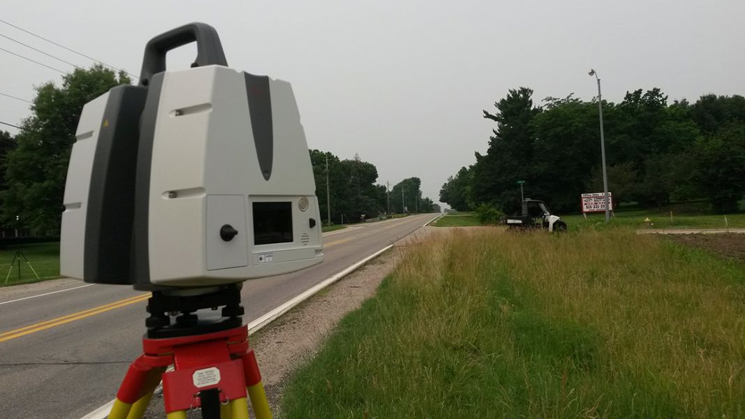
Using highly accurate 3D scan data generated with 3D scanning you are able to view as-built documentation in a virtual world. The point cloud data can also be surfaced to generate a CAD model which can be used for comparison or reconstruction.
The size of the specimen being scanned is no longer limited to the directional travel of a machine, or the reach of an arm. Scans can be taken anywhere, at virtually any time. The raw output of terrestrial scanning is “point-cloud” data, which we can use as reference to create a fully parametric file in your design software.
Laser Design uses top of the line 3D software systems and software for your project! We have experience with the latest technology and always pick the right software and 3D system for your job to ensure the best results.
3D Terrestrial Scanning Photo Gallery
The Laser Design Terrestrial 3D Team has been busy! We’ve been to the World Trade Center, the new U.S. Bank Stadium, Space Needle, Miami Airport, ships in Korea, the Mirage volcano and more! We have the experience and know-how to tackle your next project! Check out our gallery of photos.
3D Scanning Videos: AEC
3D Terrestrial Scanning Case Studies and News
- AEC 3D Scanning for Metal Panel Design
- As-Built Documentation Using 3D Scanning: 5 Benefits of 3D Scanning for Design, Engineering and New Equipment Installation in Commercial Buildings
- 5 Advantages 3D Scanning Provides for Building Information Modeling
- Application Story – 3D Scanning and Projection Mapping
- 3D Scanning of Basilica – Norfolk
- 3D Scanning of Mechanical Rooms
- Pacific Eagle Uses 3D Scanning to Rental Units into Condos
- 3D Scanning of a Hospital Boiler Room
- 3D Terrestrial Scan of Shattuck St.
 Mary’s
 - Municipal Cooling System Replaced with Minimal Downtime through 3D Scanning Services
- Long-Range Scanning Busts Crunch-Time Large-Scale Project Deadline
- Digital Recreation from the Scene of the Accident
- As Featured in Time Compression Magazine: Reverse Engineering Things to Know
List of Terrestrial Projects
The Laser Design team has provided 3D scanning services for clients in many industries around the globe. Our 3D scanning engineers work with you to get you the 3D data you need for your project. Below is a list of some of the projects we’ve worked on out in the field.
| Project | Project Overview | Equipment Used | Software Used | Client |
|---|---|---|---|---|
MSP Airport, St. Paul, MN Paul, MN | Laser scanned airport mechanical rooms and mechanical bays in the terminal. Created a 3D Revit model of the existing structural features, piping, ducts, equipment and conduit. | Leica P30 and FARO Focus 120 | Leica Cyclone, EdgeWise BIM Suite, Autodesk Recap, Autodesk Revit | Mechanical Design Company |
| World Trade Center, New York City | Laser scanning existing structural features and created a 3D model in Revit. | Faro Focus 120 | Faro Scene, Autodesk Recap, Autodesk Revit | Global Designer and Manufacturer |
| Multiple Silicon Valley Tech Company Buildings, Sunnyvale, CA | Laser scanned the interior and exterior of two 9 story office buildings and mechanical areas. Created a 3D model of all the existing MEP, architectural and structural features including the hangers on all of the MEP. | Two Leica P30/40 and FARO Focus 120/330 | Leica Cyclone, EdgeWise BIM Suite, Autodesk Recap, Autodesk Revit | Construction Company |
| Beverage Manufacturing Plants - Arizona, Wisconsin, Minnesota, Illinois, Florida | Laser scanned multiple assembly lines for design purposes and for the future placement of new assembly lines.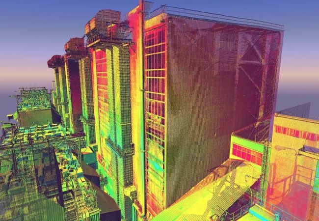 Added 3D models of designed assembly lines into the point cloud to verify clearances of proposed equipment to monitor impact on the employees and forklifts. Added 3D models of designed assembly lines into the point cloud to verify clearances of proposed equipment to monitor impact on the employees and forklifts. | Leica P30 | Leica Cyclone, Autodesk Recap, Autodesk Autocad | Beverage Manufacturer |
See full list of Terrestrial 3D scanning projects
AEC Frequently Asked Questions (FAQ)
Why should my company use 3D scanning?
3D scanning is the most effective method for collection of complete as-built measurement data.
- No return trips for additional measurements
- Millions or even billions of measurements of everything in the space.
- With our scanners all measurements are accurate to within +/- 1mm to 2mm.
Downstream benefits include:
- Reduction or elimination of field modifications when installing equipment or structural elements when 3D scanning is used in the design phase.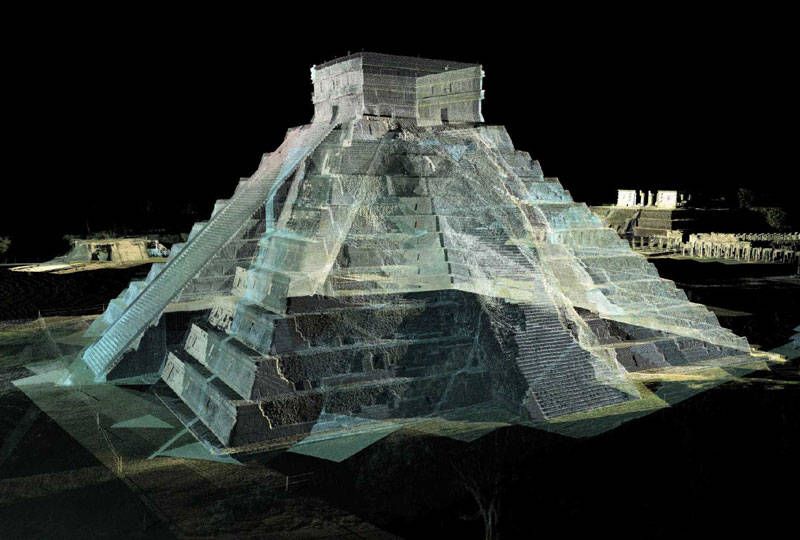
- Documentation of existing conditions for future design/build/maintenance.
- Reduce or eliminate change orders by improved design accuracy.
Why should my company use Laser Design for 3D scanning?
What types of companies can benefit from long-range 3D scanning?
How do 3D laser scanners work?
Can you set the scanner in the center of the room and capture everything in one scan?
View All
Why should my company use 3D scanning?
Why should my company use Laser Design for 3D scanning?
What types of companies can benefit from long-range 3D scanning?
How do 3D laser scanners work?
Can you set the scanner in the center of the room and capture everything in one scan?
What types of structures can 3D scanning capture?
What deliverables do we provide from 3D scanning?
What equipment do we use?
What Software do we use?
Do you provide service in multiple locations?
How do I request a quote?
Contact Us & Get Started 3D Scanning!
Ask a 3D Expert - Microsite
Construction 3D Laser Scanning - Applications
3D laser scanning in construction - applications Three-dimensional technologies today solve various problems in construction and architecture, making it possible to speed up and simplify the design process.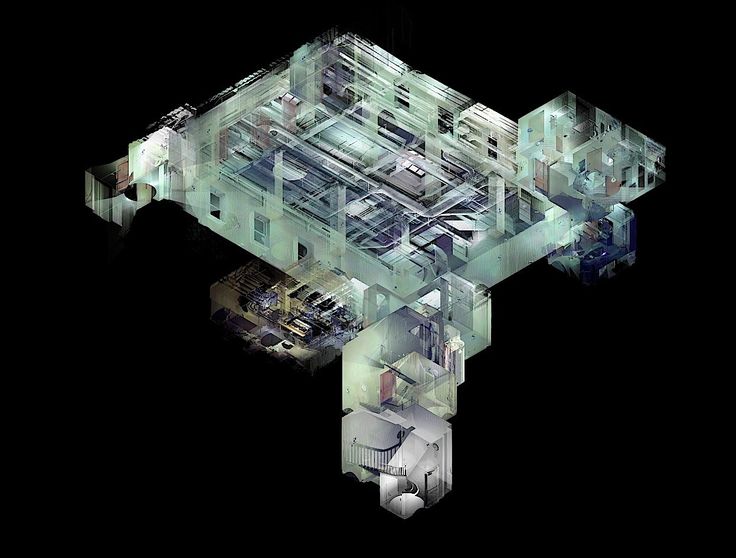
3D modeling of buildings, structures, premises, monuments and other objects helps to quickly convey ideas to the customer and make adjustments at any stage of the project.
If you are faced with the task of reconstructing or modernizing an object, developing technical documentation, or measuring the geometry of a building with high accuracy, you can get a 3D model using an industrial 3D scanner.
A 3D printer in architectural and construction projects makes it possible to quickly create realistic and accurate models of any architectural projects.
Production tasks
Direct production of end product and tooling
3D Prototyping
Reverse engineering (reverse engineering)
Geometry control
Measurement of buildings and premises for reconstruction / redevelopment
Creation of digital archives
Design to optimize part geometry
Research and educational tasks
3D model making
Training
Additive manufacturing and 3D scanning
Fundamentals of 3D printing and 3D scanning, practical skills in working with equipment and software
Find out moreCreating a polygonal model in Geomagic Wrap from a point cloud (advanced course)
Step-by-step process for creating a polygon model from a point cloud and correcting .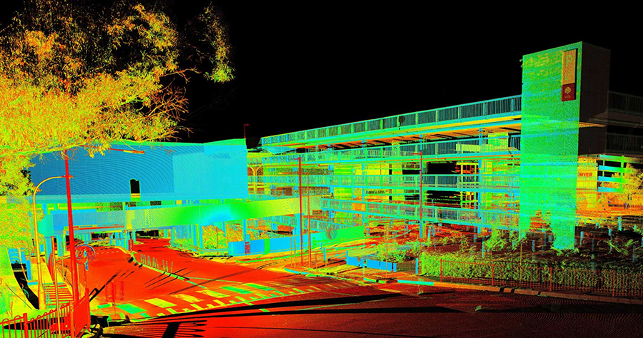 ..
..
Infrastructure design with 3D scanning
Point cloud processing with Autodesk ReCap, skills in Autodesk InfraWorks and...
Find out moreHardware and software
-
Super Discovery 3D Printer Hybrid
-
Super Discovery 3D Printer Compact
-
Creaform HandySCAN BLACK and BLACK|Elite 3D Scanner
-
Creaform MetraSCAN BLACK and BLACK|Elite 3D Scanner
-
Creaform Go!SCAN SPARK
3D scanner -
FARO Focus S70 3D Scanner
-
FARO Focus S150 3D scanner
-
FARO Focus S350 3D Scanner
-
FARO Focus M70 3D scanner
-
Creaform MetraSCAN‑R BLACK™|Elite HD 3D Automated Scan System
-
Creaform MetraSCAN‑R BLACK™|Elite 3D Automated Scan System
-
Creaform CUBE‑R Automated 3D Scanning System
-
FARO Freestyle 2 3D Scanner
-
Creaform ACADEMIA 20 3D Scanner
-
Creaform ACADEMIA 50 3D scanner
-
Creaform HandySCAN 307 3D Scanner
-
Creaform HandySCAN 700 3D Scanner
-
Creaform MaxSHOT Next and Next|Elite Photogrammetry
-
Creaform HandyPROBE Next and Next|Elite Portable CMM
-
FARO Focus Premium 3D scanner
-
Materialize Magics RP
-
Materialize e-Stage software product
-
Materialize 3‑matic software product
-
Build Processor EOS Plastics
-
Materialize Magics educational software
-
Software Product Materialize Magics Slice Module
-
Materialize Magics SG Module
-
Software Product Materialize Magics SG+ Module
-
Software Product Materialize Magics Sinter Module
-
Materialize Magics Import Module
-
Materialize Magics Tree Support Module
-
Materialize Magics Tetrashell Module
-
Materialize Magics Rapid Fit Module
-
Geomagic Design X software product
-
Geomagic Control X software product
-
Geomagic Wrap Software
-
Geomagic for SolidWorks software
-
Geomagic educational software
-
Creaform VXelements software product
-
Creaform VXmodel software product
-
Creaform VXinspect and VXinspect|Elite software product
-
Creaform VXscan‑R Software Product
-
FARO SCENE
software product -
FARO Software Product As-Built
-
FARO BuildIT software product
-
Wiiboox W1000, W1200 3D printer
-
Wiiboox W500 3D printer
-
Wiiboox W400 3D printer
-
Wiiboox W600 Pro 3D Printer
-
EPiC EasyScan T10 terrestrial laser scanner
3D Laser Scanners: Applications and Model Overview
A 3D model of an object can be created using a laser beam - this is one of the 3D scanning methods in construction and architecture. This technology is non-contact, does not cause damage to objects during scanning. As the main calculation of the amount of work for reconstructions, repairs or redevelopment, data on the dimensions of a building, structure or premises are used.
Purpose of laser scanners
There are many laser scanners for construction on the modern market. Their difference from conventional measurement methods is that 3D scanners are able to digitize complex surfaces, as well as perform measurements in inaccessible areas. The main areas of use of devices are input and output quality control at the enterprise; checking working tools to prevent and eliminate defective places; reverse engineering, as well as other areas of application.
Compared to conventional geodetic surveying, the creation of 3D models is a more informative tool for studying the territory and determining its boundaries, which allows you to obtain the most accurate information. You will be able to find out how much the geometry of the building is curved, as well as how to bring all the elements into one plane.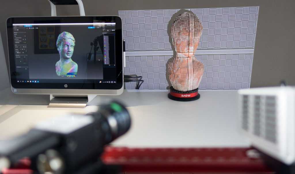 At the same time, measurements of distances between the extreme and middle points of buildings will not have a significant deviation from the norm.
If you need to scan buildings, premises or industrial facilities, contact our specialists - they will quickly solve your problem.
Order service
What is laser scanning?
During the calculation of the amount of work of modernization, repair of a building or structure, information about all the geometric features of the construction object is used. The scanner creates a cloud at a point in space with its own coordinates, and also provides a three-dimensional image of the object. For example, as an example, we can give an object model with many thousands, millions of coordinates. All these actions are aimed at obtaining accurate and effective data.
The scanning technology is similar to using a radar. It is based on laser radiation, which has a certain frequency and is reflected on a rotating mirror. Further, after the target has been detected, the beam reaches it and goes back to its original position. At this time, the 3D construction scanner determines the moment of return and receives data on the distance between the target and the observer. As a result, a cloud of points is formed. Among other things, it is worth mentioning that the device can simultaneously send several beams to a certain area of an object, and you can easily get information about the large details of the object.
3D scanners work on non-contact technology and are automated devices with a moving measuring head that rotates horizontally and vertically by 360 degrees. The engineer does not need to use additional buttons to use the rangefinder, as well as to record the desired coordinates - he can simply pick up the device and start measuring.
Basic laser scanning
When choosing the type of survey, it is necessary to take into account the complexity of the scanned structure, its overall dimensions and functional properties.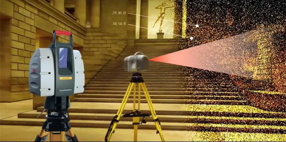
- Terrestrial laser scanning. Carried out using special terrestrial 3D scanners for construction. With the help of an optical sight or by means of preparatory scanning at a low density of coordinates, an image of the object is created. At the next stage, a thorough modeling of each section of the terrain is carried out and further collection of all the information received into a single whole. When carrying out such work, there is no need to install special markers and labels.
- Mobile scanning. The survey is carried out using the same devices mounted on various modes of transport (for example, on cars, ships or railway cars), which moves along the established path and collects the necessary data. The scanners are built to withstand vibration, displacement, and thermal distortion to avoid any inaccuracies that can occur when shooting on the go. This type of scanning is most often used to survey large areas at a distance of up to several hundred meters.
- Airborne laser scanning. The method allows you to obtain detailed images of the area, which will take into account all the features of the landscape and relief. This option involves the installation of a certain tiering so that in the future it will be possible to work separately with the entire infrastructure system, as well as with land, buildings and other objects.
Advantages of the laser scanning method
Compared with classical technologies, laser measurements have a number of advantages. With the help of a 3D scanner, you can quickly obtain the maximum possible amount of data and then develop a detailed three-dimensional layout of the object. This technology allows you to save all the information about various objects, including cultural monuments, residential areas, industrial buildings or areas of the area - all this can then be used in specialized programs for planning, repair, design and construction.
The advantages of laser scanning include:
- High image quality.
 Laser equipment has a minimum error. It is possible to configure the scanners so that they capture the first or final reflection. In particular, it will help to distinguish between different types of surface, for example, soil, grass, and others.
 - Informativeness. With the help of laser instruments, it is possible to form digital models with the display of the smallest details due to the fact that the instrument forms a cloud of more than a million points with three XYZ coordinates.
- Fast 3D real-time visualization. With the help of innovative scanners, you can get all the results in the form of a 3D model. Therefore, there is no need to spend an additional amount of time processing information, and also to involve experts.
- Security. Laser scanning in construction is the best option for scanning dangerous and hard-to-reach places. Three-dimensional systems and their field of view will provide an opportunity to obtain information about an object from a safe position.
- High degree of automation. Today, 3D scanning technology is the simplest and most automated method in existence. To start measurements, just press one button on the device.
Technology deficiencies
To evaluate the technology of 3D scanning in construction, it is necessary to take into account its disadvantages. However, now they are rarely seen, as scanners are regularly upgraded, and more and more advanced options are formed.
Now we can note some difficulties when working with a 3D scanner:
- Certain models of scanners do not have the ability to work at low temperatures down to 0°C, which creates certain difficulties for using the devices in the winter. Recently, new devices have appeared on sale that can operate up to -20 degrees, but they are often more expensive and not all companies can afford them.
- There are a number of difficulties with the automatic transfer of data to specialized programs that are designed to measure and analyze building and architectural objects using a laser.
 Most of these programs that describe buildings use the most common geometric shapes. Naturally, when modeling the architecture of objects or interiors, you will have to transfer some information manually.
Currently, laser measurements of objects are not completely automated. Of course, technology makes it possible to avoid many difficulties in work, as well as complex and dangerous measurements. But if you want to get the most complete picture, then you will have to work with a professional who will correctly place points for shooting, as well as plan scanning sessions.
iQB Technologies offers you to buy a construction 3D scanner at affordable prices, with delivery in Moscow and beyond. The price depends on the characteristics of the model, scanning accuracy and additional functionality.
Company *
E-mail *
Telephone *
Message
Software product
Magics RP
Import Module
Sinter Module
Structures Module
SG Module
Tree Support Module
SG+ Module
Simulation Module
Slice Module
Select 3D printing material from the list *Photopolymer Metal
Software product
Geomagic Design X
Geomagic Control X
Geomagic for SolidWorks
Geomagic Wrap
Company *
E-mail *
Telephone *
Subscribe to blog
Subscribe to news
An error occurred
Please try again later!
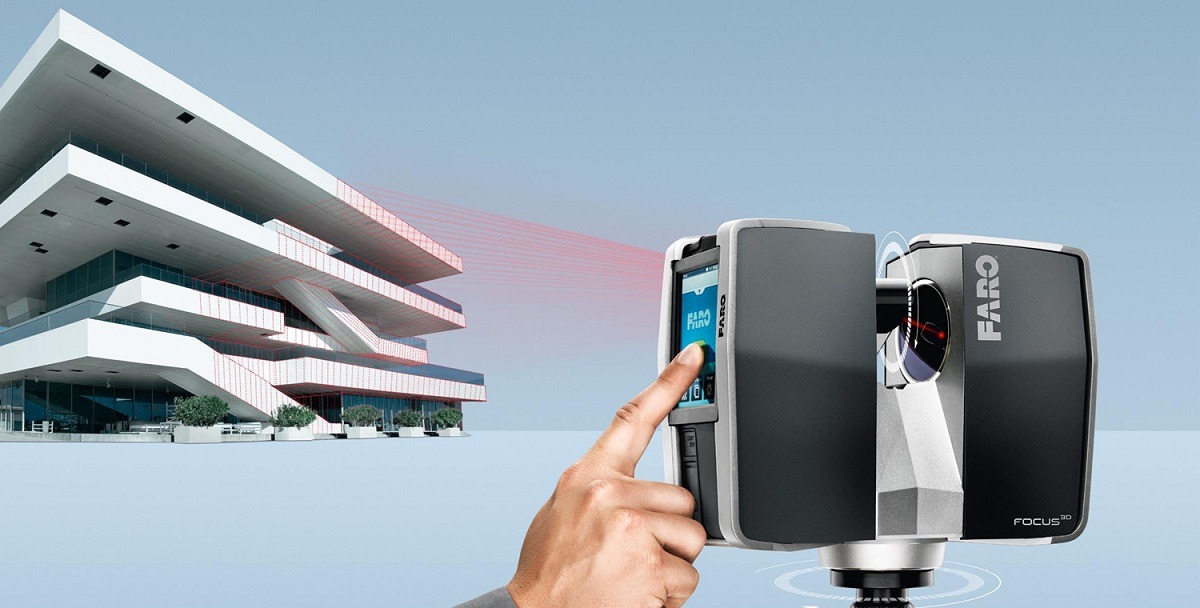
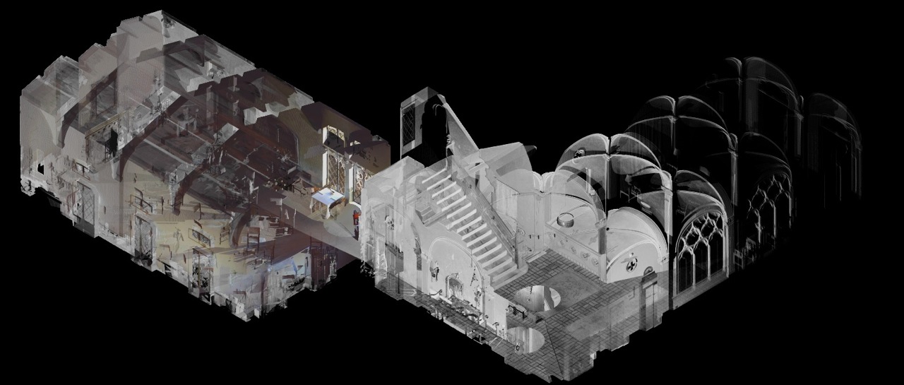
3D scanners in architecture and restoration
Supplier of 3D equipment since 2010
+7 495 646-15-338 800 333-12-82
3D Scanners3D PrintersSoftwareServices
About the CompanyClients and ProjectsDemo HallGovernment ProcurementDeliveryService3D Encyclopedia
BlogContacts
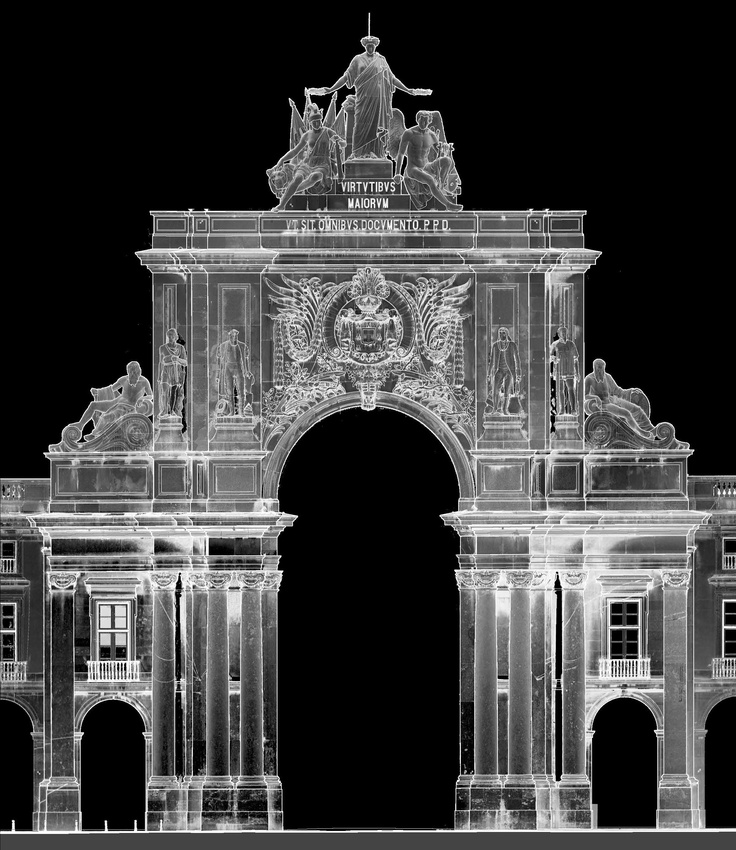
3D scanners are widely used to quickly digitize buildings and premises, as well as museum exhibits. 3D technologies significantly speed up the preparation of a ready-made design solution. Digitization of ancient monuments or buildings subject to restoration, fixing the circumstances of traffic accidents or crime scenes is far from a complete list of what is possible.
Using 3D scanning technology, you can create an accurate three-dimensional digital model of the surrounding space and objects in a matter of minutes, whether it is the interior decoration of a room or the facade of a building.
Endless possibilities
Making high-precision measurements of a terrain or object and recreating it as a model has always been one of the most pressing engineering challenges. But until recently, it was possible to obtain the most accurate and realistic image only on flat two-dimensional plans and maps. Now this problem is easily solved by a 3D scanner.
Using 3D scanning technology, you can create an accurate three-dimensional digital model of the surrounding space and objects in a matter of minutes, whether it is the interior decoration of a room or the facade of a building.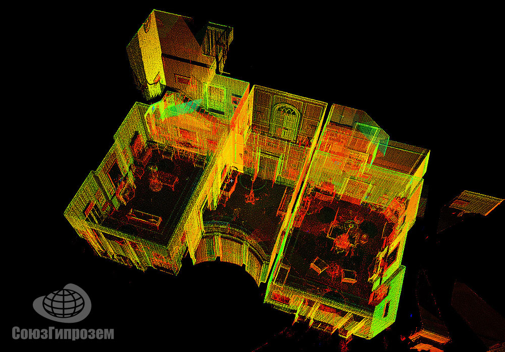
Architectural scanners easily perform geometric measurements, geodetic support for the design and installation of facade structures, control of deformations when a load is applied to the structure, three-dimensional modeling of buildings, streets and quarters, drawing up detailed plans. Scanners cope with the restoration of project documentation, the creation of working drawings and road mapping.
Types of scanners
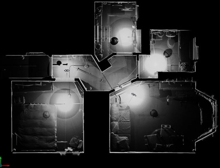
3D devices used in construction can be divided into two main groups: facade and interior scanners.
Facade scanners are designed to scan the exterior of buildings, open areas and other large objects. As a rule, such a survey is made from several points on the ground.
Interior 3D scanners are designed to digitize tight enclosed spaces: small rooms, engineering channels, caves, tunnels, voids, etc. Such scanners are inferior to facade devices in terms of scanning range, but they capture more details. Both facade and interior 3D scanners consist of a digital video camera and a scanning system.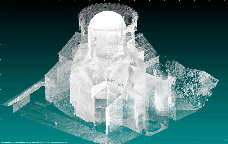 The scanning system simulates the shapes of the measured objects, and the camera provides accurate color reproduction.
Architectural scanners easily perform geometric measurements, geodetic support for the design and installation of facade structures, control of deformations when a load is applied to the structure, three-dimensional modeling of buildings, streets and quarters, drawing up detailed plans. Scanners cope with the restoration of project documentation, the creation of working drawings and road mapping.
Types of scanners
3D devices used in construction can be divided into two main groups: facade and interior scanners.
Facade scanners are designed to scan the exterior of buildings, open areas and other large objects. As a rule, such a survey is made from several points on the ground.
Interior 3D scanners are designed to digitize tight enclosed spaces: small rooms, engineering channels, caves, tunnels, voids, etc. Such scanners are inferior to facade devices in terms of scanning range, but they capture more details.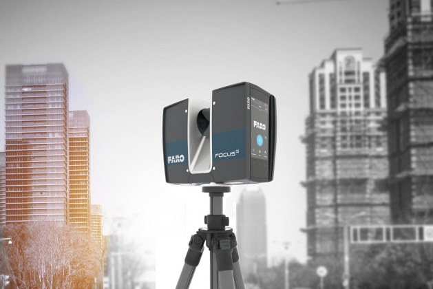 Both facade and interior 3D scanners consist of a digital video camera and a scanning system. The scanning system simulates the shapes of the measured objects, and the camera provides accurate color reproduction.
Scanning accident scenes
Architectural scanners have proven themselves in digitizing accident scenes. This work is well illustrated by a case that occurred in the state of Louisiana, USA. The scanner allowed the police to fix all the necessary parameters at the crash site with an accuracy of 2 mm: the relative position of cars with reference to the terrain, braking marks, scree of dirt and broken glass, and physical damage to vehicles. This operation was carried out very quickly, fixing the facts before they were washed away by a hurricane a few minutes later.
Scanning accident scenes
Architectural scanners have proven themselves in digitizing accident scenes. This work is well illustrated by a case that occurred in the state of Louisiana, USA.