Leica 3d scanner price
Leica ScanStation P40 3D Laser Scanner
- Main Categories
- Laser Scanners - 3D
FLT P/N #:LCA6009377 In Stock
List Price: $84776.45 or [Request a Quote]
Authorized Dealer
[ Return to the Previous Page ]
| Quantity |
| Click on the image for a larger view. |
The Leica ScanStation P40 offers the highest versatility including long range (up to 885 ft/270m at 34% reflectivity), speed (up to 1 million points per second), and accuracy (3D positional accuracy of 3mm at 50m; 6mm at 100m).
The right choice
Whether capturing 3D geometry of civil infrastructure, creating an as-built representation of a large industry complex, reconstructing a crime scene or generating 3D data for integration into Building Information Modelling (BIM), you know youll need an accurate long range scanning tool for your projects the new ScanStation P30 and P40 laser scanners from Leica Geosystems are the right choice, because every detail matters.
High performance under harsh conditions
The Leica ScanStations deliver highest quality 3D data and HDR imaging at an extremely fast scan rate of 1 million points per second at ranges of up to 270 m. Unsurpassed range and angular accuracy paired with low range noise and survey-grade dual-axis compensation form the foundation for highly detailed 3D color point clouds mapped in realistic clarity.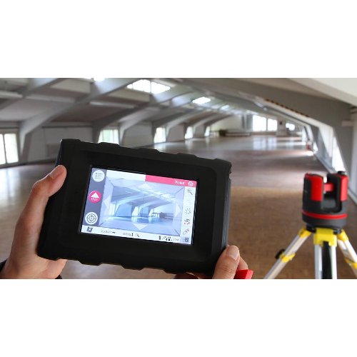
Reduced downtime
The extremely durable new laser scanners perform even under the toughest environmental conditions, such as extreme temperatures ranging from 20C to + 50C and comply with the IP54 rating for dust and water resistance.
Complete scanning solution
Leica Geosystems offers the new Leica ScanStation portfolio as an integrated part of a complete scanning solution including hardware, software, service, training and support. 3D laser scanner data can be processed in the industrys leading 3D point cloud software suite, which consists of Leica Cyclone stand-alone software, Leica CloudWorx plug-in tools for CAD systems and the free Leica TruView.
- Features
- Specifications
This Leica ScanStation P40 Standard Package includes:
● 1x ScanStation P40 laser scanner (827494)
● 1x GVP645 transport box (769625)
● 1x GDF323 Tribrach without optical plummet (777970)
● 4x GEB242 Lithium-Ion Battery (793975)
● 1x GKL311 Single charger Prof 3000 (799185)
● 1x GEV228 data cable (766567)
● 1x GHM008 Scanner height meter (772829)
● 1x GHT196 Distance holder for height meter (722045)
● 1x ScanStation P40/P30 Quick Guide
● 1x ScanStation P40/P30 System USB Stick
● 1x Cyclone CD (755609)
● 1 year CCP Basic contract (6009442)
See data sheet below
View/Download P30/P40 Data Sheet
Related Products
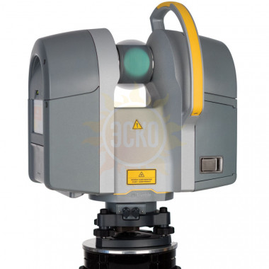
Leica RTC360 3D Laser Scanner
- Description
- Additional information
- Download Data Sheet
- Request a Quote
- Reviews (0)
Description
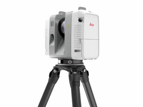
The Leica RTC360 3D Laser Scanner is a fast, agile and precise 3D reality capture solution.
The RTC360 3D laser scanner makes 3D reality capture faster than ever before. With a measuring rate of up to 2 million points per second and advanced HDR imaging system, you can have 3D color point clouds in under 2 minutes. Plus, automatic targetless field registration (based on VIS technology) and the seamless transfer of data from site to office reduce time spent in the field. Therefore, maximizing your productivity.
VIS – Visual Inertial System
Contrary to other scanners, the RTC360 offers Real Time Registration, an automatic point cloud alignment from real time tracking of scanner movement between setups. Highly portable, automatic, intuitive and efficient, the RTC360 solution combines the RTC360, Leica Cyclone FIELD 360 and Leica Cyclone REGISTER 360 office software.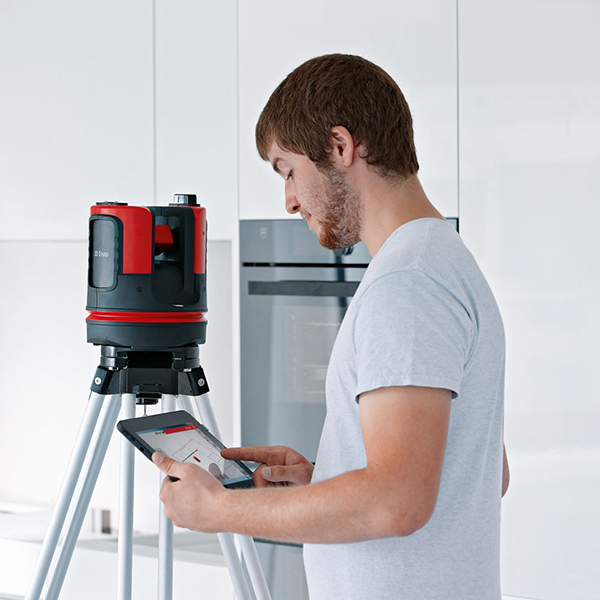 Leica Cyclone FIELD 360 is a mobile-device app for edge computing for automatically registering scans in real time. Use Leica Cyclone REGISTER 360 to seamlessly integrate 3D models into your workflow. Capture scans, including enriching High-Dynamic Range (HDR) imagery, in less than two minutes. Automatically record your moves from station to station. Therefore, you can pre-register your scans in the field without manual intervention. Augment your data capture with information tags. As a result, you can illustrate the opportunities for better planning, reflect site reality, and boost your teams’ situational awareness
Pre-Registration in the Field
Unlike any other scanner, the RTC360 pre-registers the data in the field, in real-time. Using Cyclone Field 360 and Cyclone REGISTER 360, the 3D data acquisition in the field is linked with the laser scanner and data registration in the office. The user can automatically capture, register and examine scan and image data on-site. Not only does the interface easily handle complex calculations, but it also has a graphical user guide. Without a doubt, it is a remarkable experience, even for novice users.
What You Get: Leica RTC360 3D Laser Scanner, Transport Container for RTC360 and Accessories, 4x GEB361 Lithium Ion Battery. GKL341 Charging Station, 2x 256 GB Flash Drive, Rain Cover, 1 yr RTC360 Laser Scanner Basic CCP, and Quick Guide; Tablet not included
Additional information
| Weight | 30 lbs |
|---|---|
| Dimensions | 4.7 × 9.4 × 9.10 in |
Download Data Sheet
Download Data Sheet
Request a Quote
Only logged in customers who have purchased this product may leave a review.
You may also like…
-
GST80 Lightweight Tripod
Rated 0 out of 5
$2,550.00Add to cart -
Leica Cyclone REGISTER
Rated 0 out of 5
$8,450. 00Select options
 -
GVP736 Backpack
Rated 0 out of 5
$455.00Add to cart -
Leica Cyclone REGISTER 360
Rated 0 out of 5
$4,400.00 – $9,750.00Select options
Previous - Next
Leica RTC360
price on request
Order
Warranty - 1 year.
Article - 6015268.
fast, compact, accurate, for digitizing objects Leica RTC360 Brochure
The Leica RTC360 is a new scanner from Leica Geosystems with a compact design that scans up to 2 Mpts per second, twice as fast as ever before. This device is a professional solution and is designed to work both in the office and in the field. Just like the BLK360, the RTC360 can easily perform high-performance scanning of objects up to 130 meters away, generating a colorful 3D HDR point cloud in less than 2 minutes. The built-in inertial system VIS (Visual Inertial System) performs snapping to reference points and automatically captures the movements of the scanning station, allowing you to significantly simplify the processing of field results in the office, as well as save your time. nine0003
Features:
- Automatic scan stitching thanks to built-in inertial system
- Scanning speed 2,000,000 points per second
- Automatic filtering of moving objects
Using the highly automated RTC360 handheld 3D scanner in conjunction with the Leica Cyclone FIELD 360 field software for mobile devices for automatic real-time scan registration and the Leica Cyclone REGISTER 360 for fast and accurate alignment of point clouds taken from different survey locations. The Leica RTC360 scanner can serve as an excellent solution for creating virtual reality VR and augmented reality AR. Remote demonstration of the project implementation to investors, monitoring the progress of construction, viewing apartments and houses in real estate agencies, viewing hotels and landscaping of the adjacent territory in travel agencies, test drives of new cars, showrooms and much more. With RTC360 digital twins of any objects can be created! nine0003
Forensic, Industrial, Civil Infrastructure, Architecture, Construction & BIM, Mine Surveying & Tank Calibration
Rapid and accurate data collection enables police to expedite the collection of evidence for crime scene or traffic accident analysis. The compact dimensions of the RTC360 laser scanner and the IP54 dust and moisture protection standard make it possible to carry out 3D scanning quickly and easily under various weather conditions.
The fastest scanning speed, good data quality and resistance to difficult conditions make the RTC360 laser scanner a versatile 3D data acquisition tool for industrial renovation and construction tasks. Lack of illumination, congestion of communications, unstable sites and vibrations will not affect the quality of the data. The level of detail and high-quality photorealistic data make it possible to analyze mechanisms, bodies, bodies and eliminate defects at the early stages of manufacturing elements. This makes it possible to save time and money. nine0041 Capturing 3D geometry of roads or railroad tracks, tunnels, bridges and other built-up areas - for such tasks it is necessary to have a device that combines speed, accuracy and reliability. For serious engineering and infrastructure projects, the RTC360 laser scanner is the right choice, because every detail counts!
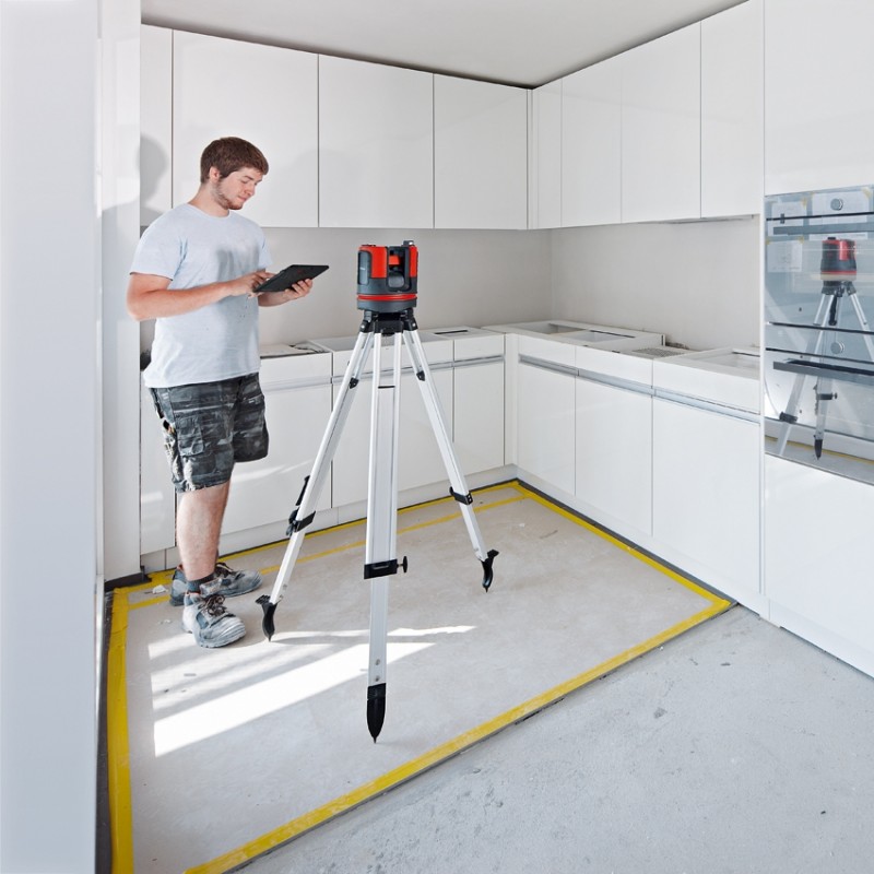
The introduction of BIM standards in design and construction requires a change in data collection approaches. Laser scanning technology fully meets the requirements in this area, as it allows you to get the maximum amount of data per unit of time without loss of quality. Which, in turn, makes it possible to quickly monitor the situation at the construction site and make the necessary adjustments in time, saving time and money. The portable design of the Leica RTC360 scanner and lightweight telescopic tripod allow you to pack the scanner compactly into a regular backpack and scan quickly and easily. nine0041 Determining the volumes of embankments and recesses in a matter of minutes, building contours and figures of reservoirs, calculating the volume in 1 mm steps - all this became possible using laser scanning technology. It is important to note that the RTC360 scanner can be controlled remotely using a tablet, which will make your work as safe and easy as possible. The compact size of the instrument opens up new possibilities for you in laser scanning with Leica Geosystems instruments.
WARNING! Apple iPad Pro tablet not included.
The scanner is mounted on a special tripod for BLK360, or on any photo tripod using an adapter.
Do you have an interest in similar products but find it difficult to choose? - there is a simple way out - ask a question to SEREGIN SERGEY LEONIDOVICH (ext. 116), Leading specialist of our company in the field of photogrammetry and laser scanning, with 20 years of experience and dozens of completed projects! nine0041 Call, we guarantee that time will not be wasted.
| Tool type | High-speed, compact laser scanner with inertial imaging system |
|---|---|
| Data memory | Built-in 64 GB SSD |
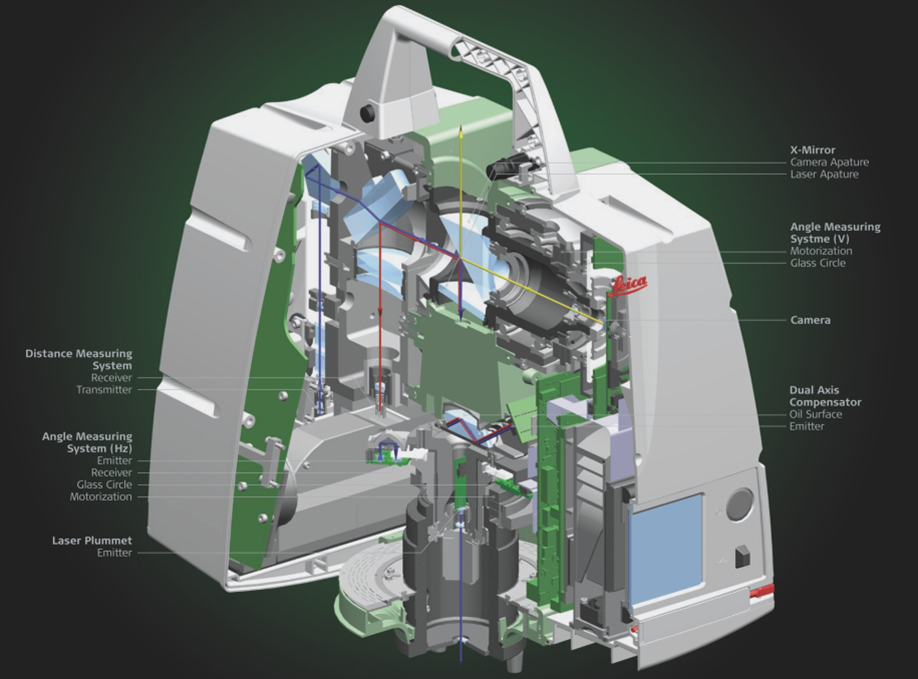
| Camera | 3-camera system 36 MP, 300° spherical image; system of 5 B&W cameras for automated binding |
| Angular accuracy | 18" |
| Distance accuracy | 1. 0 mm + 10 ppm 0 mm + 10 ppm |
| 3D position | 1.9mm at 10m / 2.9mm at 20m / 5.3mm at 40m |
| Scan speed | up to 2,000,000 points/sec |
| Measuring range | nine0062 0.5 m to 130 m|
| Field of view (horizontal/vertical) | 360° / 300° |
| Laser class | -1 (IEC 60825-1:2014), wavelength - 1550 nm (invisible) |
| Battery type | Internal: 2 x GEB361 Li-Ion; External: GEV282 Li-Ion with adapter |
| Operating temperature | -5° .. +40°C | nine0064
| Storage temperature | -40° .. +70°C |
| Protection standard | IP54 |
| Lighting | Operates in total darkness and bright light |
| Weight | 5. 35 kg 35 kg |
| Scanner dimensions | 100 mm x 100 mm x 165 mm |
Forensics, industry, civil infrastructure, architecture, construction and BIM, mine surveying and tank calibration
RTC360 laser scanner
Transport case
Leica GEB361 battery - 4 pcs.
Leica GKL341 charger
Leica RTC360 USB Flash Drive 256 GB storage - 2 pcs.
Rain cover
Call request
How to contact you* nine0003
Telephone*
Time to call (Moscow time)
s on
Comments
* — required fields
nine0004 By clicking the "Submit" button, you consent to the processing of personal data in accordance with privacy policyFeedback
If you have any questions, write to us and we will definitely answer.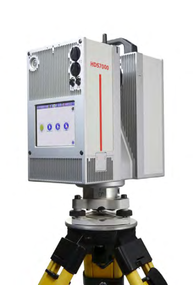
Message *
Your name *
nine0002 Email *By clicking the "Submit" button, you consent to the processing of personal data in accordance with privacy policy
Leave a request
Your order
Cost* * — the cost depends on the configuration
How to contact you*
Telephone*
E-mail*
Organization
Comments
* — required fields
By clicking the "Submit" button, you consent to the processing of personal data in accordance with privacy policy
Leica RTC360 3D Laser Scanner | Leica Geosystems
- home
- Products/Solutions nine0030
- Laser scanners
- Scanners
- Leica RTC360 3D laser scanner nine0030
Use automatic on-site pre-registration of point cloud data for real-time quality control, increased productivity and better decision making on site
Document and digitize your environment in 3D with the Leica RTC360 3D reality capture solution. Increase productivity on site and in the office with fast, accurate, portable and easy-to-use hardware and software. With the RTC360 3D Laser Scanner, a skilled technician can overcome any design challenge with accurate and reliable 3D models to unlock the full potential of any site. nine0003
- The compact, highly automated, intuitive and user-friendly RTC360 solution includes a high-performance 3D laser scanner, the Leica Cyclone FIELD 360 mobile app for edge computing, such as automated real-time registration of scanned data, and the Leica Cyclone REGISTER 360 office software , with which you can easily implement the resulting 3D model into your workflow.
- Capture scans, including stunning HDR images, in less than two minutes. nine0030
- Automatic recording of movements between survey points to pre-register scan data in the field without manual intervention.
- Augment the collected data with informative tags with hints for optimal planning and information about the real conditions on the site, which will help your colleagues to better understand the situation.
- Upload collected data from Cyclone FIELD 360 directly to Leica TruView Cloud to quickly share design data before import and registration. nine0030
Fast
The new Leica RTC360 laser scanner captures reality in 3D at a speed never seen before. Capturing up to 2 million points per second and using advanced HDR image capture, the scanner generates colorful 3D point clouds in less than two minutes.
 Automated, labelless data logging in the field based on VIS technology and convenient automatic data transfer from site to office further speed up field work and increase productivity. nine0003
Adaptive
Thanks to its portable design and foldable tripod, the compact and lightweight Leica RTC360 fits into a regular backpack. On the object, one click of a button is enough to scan the environment without any additional settings.
Fine
nine0041 Low noise in the acquired data means better image quality – you get crisp, detailed scans that are ready for a variety of industries. Combined with the Cyclone FIELD 360 automated data logging software in the field, the Leica RTC360 delivers amazing accuracy that can be verified on site.
Pre-registration in the field
The Cyclone FIELD 360 app, part of the RTC360 solution, bridges the gap between on-site 3D data collection and on-site registration of laser scan data in the office with Cyclone REGISTER 360.
 User can automatically capture, register, and control scan and image data on site . The easy-to-learn and user-friendly graphical interface offers visual aids for complex calculations, making it easy for even beginners to master. nine0003
 Previous Next
Scanning capabilities
The RTC360 3D Laser Scanner automatically captures movement between survey points to pre-register scanned data on the spot. Juergen Mayer spoke about the latest developments in an interview with The Reporter. nine0003
Introduction to the RTC360
The latest Leica RTC360 3D reality capture solution, unveiled at HxGN LIVE 2018, combines a high-performance laser scanner with a mobile application for capturing and pre-logging real-time scan data.
From hardware to software
Geosystems specialists optimize every link of the workflow in both software and hardware solutions to increase the efficiency and productivity of field work and data processing in the office. nine0003
Leica RTC360: 3D reality capture solution
Leica Cyclone FIELD 360 mobile-device app
Downloads
Videos
EXPERT ADVICE
nine0284 Examples of using
Podcasts
Introducing the Leica RTC360 3D Laser Scanner
3D environments in a matter of minutes - an outlook on recent reality capture technology
3D reality capture - new opportunities, greater understanding
Transforming Ayacucho into a digital city
nine0284 Services
myWorld Customer Portal
Active Customer Care
Customer Support Packages
Related products
Laser scanners
Leica BLK360 laser scanner
Leica ScanStation P40 / P30
Leica ScanStation P50
Software
Leica Cyclone
Leica Cyclone REGISTER
Leica Cyclone REGISTER 360
Leica CloudWorx
Leica TruView
Leica JetStream
Accessories
Accessories for 3D laser scanners 9003
contact-for-laser-scanning
As of v7.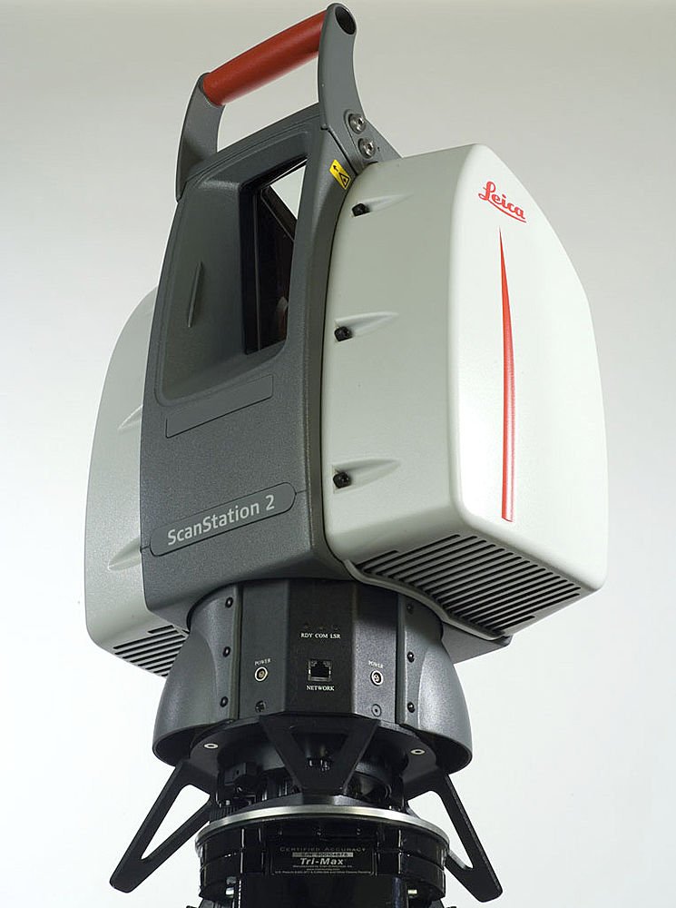 0.1, Safari exhibits a bug in which resizing your browser horizontally causes rendering errors in the justified nav that are cleared upon refreshing. nine0003
As of v7.0.1, Safari exhibits a bug in which resizing your browser horizontally causes rendering errors in the justified nav that are cleared upon refreshing.
CONTACT US
The High-Definition Surveyor - Blog
Learn how Leica Geosystems laser scanning solutions are helping professional to shape the future of our world. nine0003
Learn how Leica Geosystems laser scanning solutions are helping professional to shape the future of our world.
Read More
Scanning power
Quality is a tradition, built deep within our DNA. We have a commitment to excellence and exceptional attention to detail. nine0003
The power of scanning
Quality is a tradition, built deep within our DNA. We have a commitment to excellence and exceptional attention to detail.
WATCH NOW
Educational articles and analytics
What is 3D Reality Capture and how is it applied in your industry? nine0003
What is 3D Reality Capture and how is it applied in your industry?
learn more
Comparison table of laser scanners
Which laser scanner is right for you?
Which laser scanner is right for you?
download now
Reality Capture Newsletter
Click here to subscribe to our regular newsletter and stay up-to-date on all the latest reality capture news.