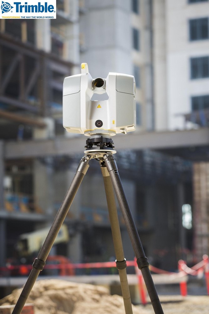
Trimble tx5 3d scanner
Trimble TX5 Laser Scanner
Lightly used year 2014, low hours used a total of 142 scans. Set up is in mint and ready to go to scan condition.
Trimble TX5 sale includes:
- Trimble TX5
- The Tripod
- Prism rod
- Bi pod included
- Trimble Scene software
- 20x sphere’s
The Trimble TX5 3D laser scanner is a revolutionary and highly versatile 3D scanning solution for a broad variety of scanning applications. The compact and lightweight design provides unmatched mobility at the job site, increasing field productivity. The intuitive and easy to use onboard interface allows new users to quickly get up to speed
- Revolutionary and versatile
- Scanning solution
- Compact / Lightweight
- Efficient
- Economical
- Ease of Use
Smallest and most compact 3D laser scanner ever built. Ultraportable design allows for operation without external devices
- Weighs just 5.
0kg (11lbs)
- 240mm x 200mm x100mm (9.5 in x 8 in x 4 in)
- Everything self-contained in small and light transport case
Trimble TX5 Key Features
- Laser Technology: Phase shift, 976,000 points per second
- Integrated color camera: Coaxial optics for accurate RGB’s
- Range: – Up to 120m
- Accuracy: – 2mm standard deviation
Data Capture Workflow
Line-of-sight technology
- Setup is more like camera than survey instrument
- Careful planning required before data capture begins
Registration options:
- Spheres (preferred)
- Paper targets
- Common scan points
- Internal sensors
Integrated Sensors
Integrated compass and altimeter in the Trimble TX5 add directional and height information to scans. Dual axis compensation adds level information to scans
- Facilitate auto-registration process
- Differentiate scans from each other
- Reduce number of needed targets
Users have more information available to speed processing and deliverable creation.
Intuitive Touchscreen Display
Control all functions through simple user interface on instrument
- Simple user interface
- Touch control
- No need for external controllers/cables
Intuitive and easy to learn user interface helps get crews up and running quickly
Scanning Workflow
Process Data
- Registration (optional)
- Analyze and measure features
- Export to CAD/GIS
- Publish to WebShare
Capture data
- Point clouds
- Images
Trimble SCENE Software
- Automatic target detection, registration of clouds
- Generates panoramic images
- Quality control, visual inspection, and navigation functions 2D and 3D Measurement tools (heights, widths, circumference, etc.)
SCENE Measurement Tools
- Measure between two or more scan points or objects
- Measure in panoramic or 3D views
- Option to display overall, horizontal and vertical distances
- Measurements can be located automatically in the future
SCENE Automatic colorization of scans
SCENE 3D View
SCENE Capable of making ”virtual” 3D Measurements on any feature
Trimble tx5 scanner - Trimble - PDF Catalogs | Technical Documentation
Add to favorites
{{requestButtons}}
Catalog excerpts
The Trimble® TX5 3D laser scanner is a revolutionary and highly versatile 3D scanning solution for a broad variety of scanning applications.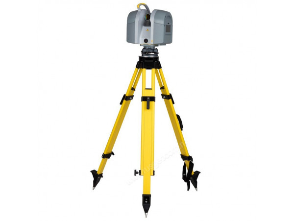 The compact and lightweight design provides unmatched mobility at the job site, increasing field productivity. The intuitive and easy to use Versatile and cost-effective solution Compact and portable Integrated color camera for photorealistic 3D laser scans Intuitive touch screen interface ideal for new users onboard interface allows new users to quickly get up to speed. High-speed scanning with integrated color camera The Trimble TX5 high-speed 3D laser scanner is able to measure at speeds of up to 976,000 pts / sec and up to a range of 120 m. The system also includes an integrated color camera featuring an automatic 70 megapixels parallax-free color overlay. The end result is detailed photorealistic 3D color images made from millions of measurements. This provides users an excellent solution for documenting existing conditions for BIM, architectural, structural deformations, industrial facilities, heritage, forensics, and accident investigation, where detail and color are required. Mobility The Trimble TX5 is the smallest and lightest scanner available.
 With a size of only 240 mm x 200 mm x 100mm (9.5 in x 8 in x 4 in) and weight of just 5.0 kg (11 lb), it is easy to move and set up in complex environments. The small and light transportation case provides users with a convenient, safe and cost effective solution for transportation. The scanner also comes with a lithium-ion battery that provides up to five hours of battery life and can be charged during operation. The option to operate via WLAN to remotely start, stop, view or download scans from a distance is also available to users. Ease of Use Operation of the Trimble TX5 is made easy with a touch screen interface that is clear and concise. The steps required to set scan parameters, manage projects and scan are intuitive and easy to learn. This greatly reduces the time needed to become productive and allows new users to be confident with the scanner operation. When combined with the benefits of working with a smaller more portable solution, the Trimble TX5 is truly one of the easiest scanners to a incorporate into your business.
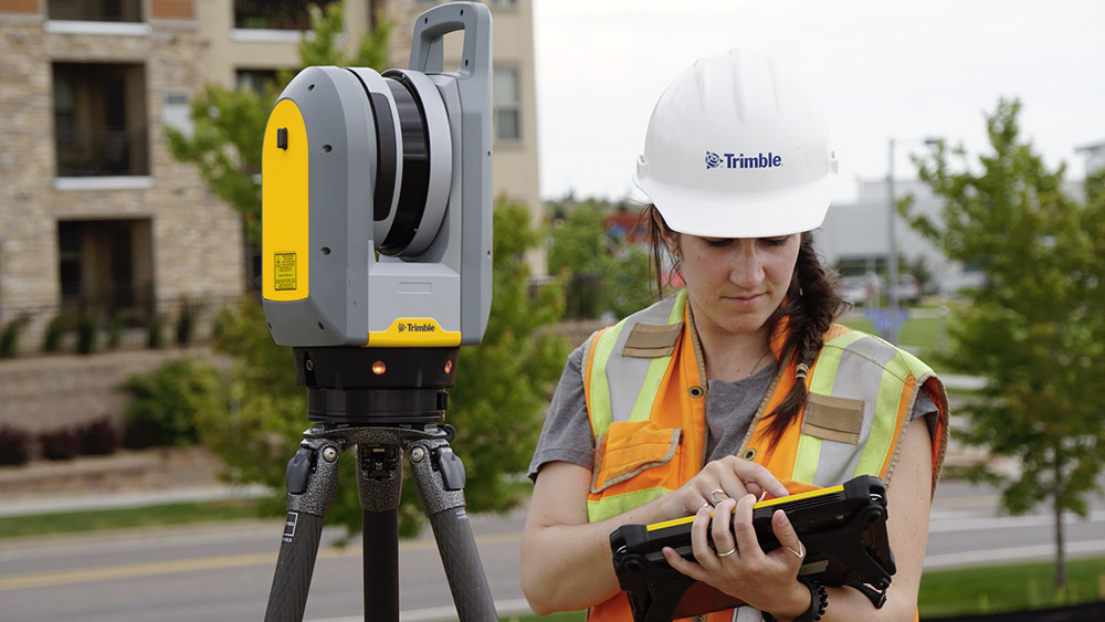 Automated Sensors The Trimble TX5 provides automated sensors to assist with scan registration and to allow a minimal number of targets needed in the field. The system has an electronic compass to associate directional data to your scans and a dual axis compensator to enable every scan to have integrated level information. A height sensor (Altimeter) provides height information to assist with differentiating scans, e.g.; different floor levels in a building. Data Management Data from the Trimble TX5 is stored on a SD card enabling easy and secure transfer to a PC. Data is processed and registered in the SCENE software and can be seamlessly imported into Trimble® RealWorks® software for the generation of end deliverables, such as inspections, measurements or 3D models. Data can also be transferred to 3D CAD packages for application with 3rd party design software.
Performance Ranging Unit Unambiguity interval. . . . . . . . . . . . . . . . . . . . . . . . . . . 153.49m (503.58ft) Range1. . . . . . . . . . . . . . . . . . . . . . . . . . . . . . . . . . . . . . . . . . . . 0.6 m–120 m indoor or outdoor with low ambient light and normal incidence to a 90% reflective surface Measurement speed . . . 122,000 / 244,000 / 488,000 / 976,000 points/sec Ranging error2 . . . . . . . . . . . . . . . ±2 mm at 10 m and 25 m, each at 90% and 10% reflectivity Ranging noise3 Hardware Specifications Power supply voltage . . . . . . . . . . . . . . . . . . . . . . . 19...
All Trimble catalogs and technical brochures
-
TSC3
2 Pages
-
Trimble TDL 450
2 Pages
-
Trimble R9s
2 Pages
-
Trimble Geo 7X
2 Pages
-
Trimble R10
4 Pages
-
Trimble DiNi
2 Pages
-
Trimble C5 & C5 HP
2 Pages
-
Trimble TSC7
2 Pages
-
Trimble SX10
4 Pages
-
Trimble Field Solutions in Surveying
12 Pages
-
TRIMBLE 450L AND 450H RADIOS
2 Pages
-
Trimble S5 Total Station
2 Pages
-
Trimble Tablet Rugged PC
2 Pages
-
TRIMBLE GNSS SURVEYING SYSTEMS
8 Pages
-
Trimble TX8 Laser Scanner
2 Pages
-
Juno 3 Series
2 Pages
-
Nomad 900G Series Handhelds
2 Pages
-
Yuma 2
2 Pages
-
Ranger 3
2 Pages
-
Juno T41
4 Pages
-
Nomad 900 Series
2 Pages
-
FARO Focus 3D X 130
2 Pages
-
DIG DEEPER
12 Pages
-
Trimble M3
2 Pages
-
Trimble VX
4 Pages
-
trimble R8 GNSS system
2 Pages
-
Trimble R10 GNSS system
2 Pages
-
Construction Positioning Solutions
8 Pages
-
Marine Construction
4 Pages
-
Site Positioning Systems
16 Pages
-
TDL 450L and TDL 450H Radio - English
2 Pages
-
Trimble GPS Systems
8 Pages
-
Trimble R3 GPS System Datasheet - English
4 Pages
-
Trimble 5600 Total Station Datasheet - English
4 Pages
-
Datasheet - DiNi Digital Level - English
2 Pages
-
Trimble Spatial Imaging Brochure - English
8 Pages
-
Trimble M3 Total Station Datasheet - English
2 Pages
-
Trimble S6 Total Station Brochure - English
8 Pages
-
Trimble GNSS Systems Brochure - English
8 Pages
Archived catalogs
-
trimble GNSS surveying systems
8 Pages
-
Trimble Navigation - Laser Distributor Catalog
16 Pages
Compare
Remove all
Compare up to 10 products
Laser Scanner Trimble TX5 Kit
All received data is stored on an internal memory card for further processing. The Trimble TX5 3D laser scanner makes it possible to perform executive surveys inside and outside buildings with complex architecture, control their deformation changes, perform scanning in order to prepare three-dimensional projects for their reconstruction, reverse engineering, etc.
The Trimble TX5 is a mid-range 3D scanner that can capture distances up to 120 m.76 thousand points per second with an accuracy of ±2 mm. The scanning head during operation covers a sector of 300 ° through the zenith, so a full cycle of shooting indoors is performed in half a turn of the system around the vertical axis.
An important advantage of the Trimble TX5 scanner is its compactness, which no other device of this type with similar performance can boast yet. In addition, the low weight and reasonable price of the Trimble TX5 sets it apart from its competitors: it is currently one of the lightest automatic models on the market. That is why the Trimble TX5 3D laser scanner provides not only high mobility, but also the ability to capture indoors and other closed spaces of very small volume, where other equipment is simply not applicable.
One of the features of Trimble TX5 is the presence of a set of integrated sensors - electronic compass, inclinometer, altimeter, which increase the efficiency of your work. These additional devices fix the orientation of the device, control its height position and verticality. This makes it easier to bind the results when performing serial shooting, and there is no need to use a large number of additional marks and auxiliary geodetic tools to ensure the subsequent "stitching" of the scan results.
An integrated auto-adjustment digital camera captures images up to 70 megapixels, capturing texture and color in detail. This simplifies further visualization when processing the point cloud obtained during scanning. In addition, the Trimble TX5 scanner's receiver captures the intensity of the received laser radiation during operation, allowing you to determine the reflectivity of scanned surfaces in grayscale, more accurately perceiving their texture.
Several temperature sensors monitor compliance with the thermal regime during the operation of the device, when overheating or hypothermia of its individual components, immediately notifying you of the need to stop shooting.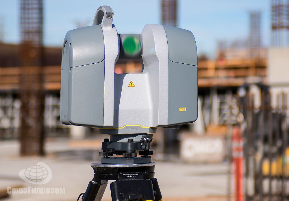 The Trimble TX5 scanner can be configured and controlled through a context menu with graphical intuitive prompts using the touch screen control panel on the side. In addition, the scanning system is equipped with a built-in wireless radio module, which allows you to control the device and access the data stored in its memory via WLAN or Ethernet using portable computers (tablet, laptop, PDA, etc.) or specialized controllers.
You can buy a Trimble TX5 laser scanner in our online store right now, or by visiting our store and inspecting the goods in person.
Technical characteristics
| 3D TRIMBLE TX5 | ||
|---|---|---|
| Type of scanner | 3R | |
| 0.6 m - 120 m | ||
| Scan speed | Humidity | 95% without condensation |
| Battery | 19 V (14. 4 in the internal battery) 4 in the internal battery) | |
| 20 MW | without recharging | 900.9 Data storage | SD, SDHC, SDXC; 32 GB card incl.0144 Trimble RealWorks Advanced software. Trimble TX5 Laser ScannerThe Trimble TX5 is an advanced laser scanner from Trimble. Light weight and compactness of the device provide comfortable work with the device throughout the working day. Trimble TX5 is used for ground scanning during surveying and engineering work.
|